

Map of 17th century Virginia
Artist
Captain John Smith
(English, 1580 - 1631)
CultureGerman | American
Date1612
MediumPaper
DimensionsOverall: 12 15/16 x 15 13/16 in. (32.9 x 40.2 cm)
InscribedTitle. English seal is near the top a little right of center. "40" at the top is written and engraved backwards. Pencil mark on back "V-Z-R".
Credit LineGift of Mrs. Louis I. Jaffé
Object number52.16.2
Not on view
DescriptionMap of Virginia. At the lower left is a compass. In the upper left Powhatan is shown seated on a platform with two Indians while a double row of men and women sit at his feet around a cooking cauldron. The upper right shows an Indian, clothed in skins, standing with a long bow and club. The longitude at the bottom is written with a line between the figures of each number and at the top to the right of this line. Paper is handmade with small lumps throughout.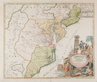

No Date

No Date

No Date

ca. 1770