
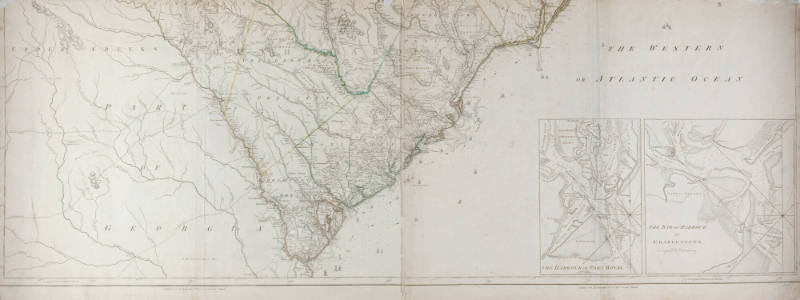
An Accurate Map of North and South Carolina with their Indian Frontiers
Artist
Henry Mouzon
(American, 1741 - 1807)
Manufacturer
John Bennett
(British, active 1760 - 1787)
Manufacturer
Robert Sayer
(British, 1725 - 1794)
CultureAmerican
DateMay 30, 1775
MediumLaid paper
DimensionsOverall: 21 x 55 1/8 in. (53.3 x 140 cm)
InscribedOn back of LR corner "Phillips #1166 List of Atlases". Also, title then "Shewing in a distinct manner all the Mountains, Rivers, Swamps, Marshes, Bays, Creeks, Harbours, Sandbanks and Soundings on the Coasts; with the Roads and Indian Paths; as well as the Boundrey and Provincial Lines, the Townships and other divisions of the Land in Both the Provinces; the whole from Actual Surveys; by Henry Mouzon and Others/London/Printed for Robt. Sayer and J. Bennett, Map and Printsellers/No. 53 in Fleet Street/Publish'd as the Act directs May 30th 1775".
Credit LineThe Chrysler Museum, Norfolk, VA
Object number59.11.1B
Not on view
DescriptionMap of North and South Carolina, showing all features, including mountains, rivers, swamps and other bodies of water, along with roads and paths, boundaries, and towns. From actual surveys. Engraved on laid paper, eight sheets mounted on cotton in two sections of four sheets each. Only a small portion of Virgina shows, not even as far up as Norfolk.


1865